


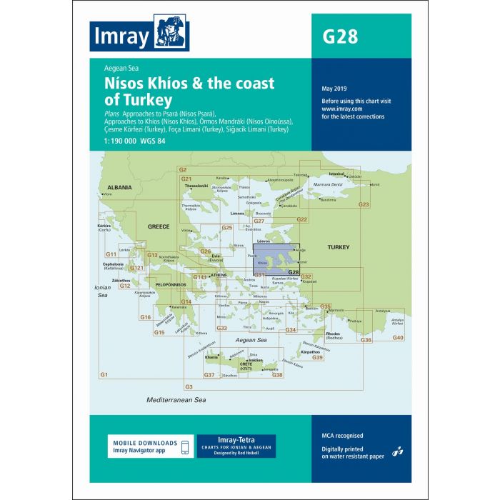
Imray G28 Nísos Khíos & the Coast of Tur
Artikelnummer
16G28
1-2 werkdagen levertijd
€ 35,50
Imray G28 Nísos Khíos & the Coast of Tur
G28 Nísos Khíos & the Coast of Turkey
Gegarandeerd de laatste editie en geen verzendkosten.De G zeekaarten van Imray zijn overzichtskaarten en detailkaarten van Griekenland, Turkije en Kreta:
Op de cover / afbeedling van de betreffende kaart vindt u de editiedatum.
Plans included:
Approaches to Psará (Nísos Psará) (1:15,000)
Approaches to Khíos (Nísos Khíos) (1:20,000)
Órmos Mandráki (Nísos Oinoússa) (1:8,000)
Çesme Körfezi (Turkey) (1:18,000)
Foça Limani (Turkey) (1:20,000)
Sigaçik Limani (Turkey) (1:18,000)
On this 2018 edition full details of the new TSS schemes are shown at Izmir Körfezi, Çandarli Körfezi and Nemrut Koyu- revised depths and harbour developments are shown at Psará, Khíos, Çesme and Foça- the Sigaçik Limani sketch plan has been replaced with a fully WGS84-compatible version- the latest known depths, restricted areas and marine farms have been applied to the main chart- and details of the recently deployed AIS transmitters are shown across the chart.
Deze zeekaarten zijn gevouwen tot A4 formaat en de totale afmeting is 787x1118mm.
Tot er een nieuwe editie wordt uitgegeven kunt u correcties downloaden via de volgende link:
https://www.imray.com/corrections/
| Landen Europa | Griekenland |
|---|---|
| Merk | Imray |
| Artikelnummer | 16G28 |
| Externe_Barcode | 9781786790156 |
| testdave5 | 0,00 |
| Serie | Imray G |
| Vaargebied | Middellandse Zee |
Advies nodig?
Verzenden
- Boven de € 50,- gratis verzonden.
- Imray uitgaven worden altijd gratis verzonden.
- Voor 16:00 op werkdagen besteld de volgende dag in huis.
Viewed by others