Imray
Imray 100 North Atlantic
€ 41,65
Imray 100 North Atlantic
Online
Direct leverbaar
In de winkel
Op voorraad
Kom langs in de winkel
Beschrijving
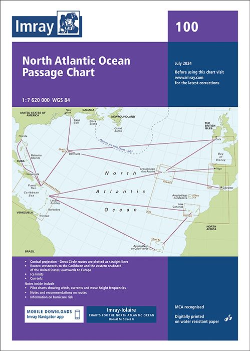
Chart 100 North Atlantic Ocean Passage Chart
De E zeekaarten van Imray zijn overzichtskaarten en detailkaarten van eilandengroepen in de Atlantische Oceaan:1. De Azoren
2. De Canarische eilanden
3. Madeira
4. Kaap Verdische eilanden
5. Bermuda
6. Ocean Passage Chart van de Noord Atlantische Oceaan
Op de cover / afbeedling van de betreffende kaart vindt u de editiedatum, de schaal en staan de diverse gedetailleerde havenaanlopen vermeld.
Groot Circel kaart. De aantekeningen binnenin bevatten pilot charts met frequenties van wind, stromingen en golfhoogte, aanbevelingen voor routes en informatie over orkaangevaar en ijslimieten.
At a scale of 1:7,620,000 this chart covers the North Atlantic from Brazil to Newfoundland and Gibraltar to the Caribbean. It has been constructed on a conical projection that means that Great Circle tracks can be plotted as straight lines rather than curves.
Chart 100 shows the main trend of depth contours, limits of ice, magnetic variations and keys routes as identified by Donald M. Street Jr. In the enclosed booklet are pilot charts showing winds, currents and wave height frequencies with accompanying notes on favourable route timings and hurricane risk.
Chart 100 is an important companion for Atlantic yachtsmen on passage and an excellent source of planning information.
Deze zeekaarten zijn gevouwen tot A4 formaat en de totale afmeting is 787x1118mm.
Tot er een nieuwe editie wordt uitgegeven kunt u correcties downloaden via de volgende link:
https://www.imray.com/corrections/
Specificaties
| testdave3 | € 0,00 |
|---|---|
| Merk | Imray |
| Artikelnummer | 16100 |
| Vaargebied | Noord Atlantische Oceaan, Centraal Atlantische Oceaan |
| Taal | English |
Gratis én snelle verzending
Bij bestellingen boven de €50
Shop de wereld van watersport
Groot assortiment met meer dan 20.000 artikelen
Gemakkelijk retourneren
Online makkelijk geregeld
De winkel van Vrolijk Watersport

Stap binnen in de winkel van Vrolijk Watersport
Wij zijn dé watersportwinkel van Scheveningen, gelegen in het havengebied.
Onze ruim opgezette winkel heeft een compleet assortiment voor zeil- en motorboten. Ook voor uw persoonlijke uitrusting is er veel keus. Merken als Musto, Helly Hansen, Gill, Secumar, Spinlock, Harken, Cobb, Omnia, Wichard, de IJssel, Plastimo, Talamex, Imray, NV Charts, ANWB en Nebo zijn het hele jaar op voorraad.