Imray
Imray 2000 Suffolk en Essex
€ 86,95
Imray 2000 Suffolk en Essex
Online
Direct leverbaar
In de winkel
Op voorraad
Kom langs in de winkel
Beschrijving
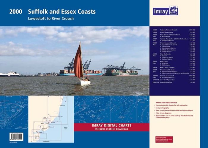
2000 Suffolk and Essex Chart Pack
Lowestoft to River Crouch
Gegarandeerd de laaste editie en zonder verzendkosten.De 2000 serie zeekaarten van Imray zijn overzichtskaarten en detailkaarten op A2 formaat van verschillende populaire kustwateren van:
1. Nederlandse kust en de Waddenzee
2. De kustwateren van de Westzijde van Groot Brittanie.
3. Het Kanaal, zowel de Engelse als de Franse kust
4. De Thamesmonding en de Oostkust van Engeland
Op de cover / afbeedling van de betreffende kaartenset vindt u de editiedatum, de schaal en staan de diverse gedetailleerde havenaanlopen vermeld.
Deze waterkaarten zijn ongevouwen tot A2 formaat en de afmeting is 590x420mm.
A pack of 10 charts for the Suffolk and Essex Coasts. The pack includes:
2000.1 Suffolk and Essex Coasts
1: 120 000 WGS 84
2000.2 Rivers Ore and Alde
1: 35 000 WGS 84
2000.3 River Deben and Orford Haven
1: 35 000 WGS 84
Plans Woodbridge, Tide Mill Yacht Harbour
2000.4 Harwich Approaches and Walton Backwaters
1: 35 000 WGS 84
Plans Walton Yacht Basin and Titchmarsh Marina
2000.5 Rivers Stour and Orwell
1: 35 000 WGS 84
Plans Upper Orwell to Ipswich, Fox’s Marina, Woolverstone Marina, Suffolk Yacht Harbour, Shotley Marina
2000.6 River Blackwater
1: 35 000 WGS 84
Plans Maldon, Tollesbury Marina, Bradwell Marina
2000.7 River Colne
1: 35 000 WGS 84
Plans Wivenhoe, Brightlingsea
2000.8 River Crouch Entrance
1: 35 000 WGS 84
2000.9 Rivers Crouch and Roach
1: 35 000 WGS 84
Plans Fambridge Yacht Haven, Bridgemarsh Marina, Burnham Yacht Harbour, Continuation of River Crouch
2000.10 Orford Ness to Lowestoft
1: 90 000 WGS 84
Plans Lowestoft Approaches, Lowestoft Harbour, Lowestoft Harbour - Lake Lothing, Southwold Harbour
For this February 2018 edition the latest depth surveys have been applied. The latest wind farm information is included where relevant.
There has been general updating throughout.
The 2018 edition is now wirobound and tidal stream information is included. Individual sheets of this atlas will no longer be sold separately. However, 1st edition charts Y2, Y6 and Y12 are to be published and are replicas of charts 2000.2, 2000.1 and 2000.5 respectively.
Imray Digital Charts: Free mobile download
A voucher code to download the relevant Imray digital charts into our Imray Navigator app is included with this atlas.
Tot er een nieuwe editie wordt uitgegeven kunt u correcties downloaden via de volgende link:
https://www.imray.com/corrections/
Specificaties
| testdave3 | € 0,00 |
|---|---|
| Landen Europa | Verenigd Koninkrijk |
| Merk | Imray |
| Artikelnummer | 162000 |
| EAN | 9781786794536 |
| Serie | Imray Sets |
| Vaargebied | Noordzee |
| Taal | English |
Gratis én snelle verzending
Bij bestellingen boven de €50
Shop de wereld van watersport
Groot assortiment met meer dan 20.000 artikelen
Gemakkelijk retourneren
Online makkelijk geregeld
De winkel van Vrolijk Watersport

Stap binnen in de winkel van Vrolijk Watersport
Wij zijn dé watersportwinkel van Scheveningen, gelegen in het havengebied.
Onze ruim opgezette winkel heeft een compleet assortiment voor zeil- en motorboten. Ook voor uw persoonlijke uitrusting is er veel keus. Merken als Musto, Helly Hansen, Gill, Secumar, Spinlock, Harken, Cobb, Omnia, Wichard, de IJssel, Plastimo, Talamex, Imray, NV Charts, ANWB en Nebo zijn het hele jaar op voorraad.