Imray
Imray 2100 Kent Coast Pack
€ 86,95
Imray 2100 Kent Coast Pack
Online
Direct leverbaar
In de winkel
Op voorraad
Kom langs in de winkel
Beschrijving
2100 Kent and Sussex Coasts Chart Pack
Thames Estuary to the Solent
Gegarandeerd de laaste editie en zonder verzendkosten.De 2000 serie zeekaarten van Imray zijn overzichtskaarten en detailkaarten op A2 formaat van verschillende populaire kustwateren van:
1. Nederlandse kust en de Waddenzee
2. De kustwateren van de Westzijde van Groot Brittanie.
3. Het Kanaal, zowel de Engelse als de Franse kust
4. De Thamesmonding en de Oostkust van Engeland
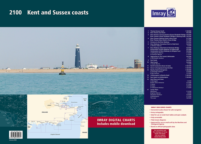
Op de cover / afbeedling van de betreffende kaartenset vindt u de editiedatum, de schaal en staan de diverse gedetailleerde havenaanlopen vermeld.
Ook staan daar alle kaarten die tot deze set behoren, met vermelding van de schaal.
Deze waterkaarten zijn ongevouwen tot A2 formaat en de afmeting is 590x420mm.
Tot er een nieuwe editie wordt uitgegeven kunt u correcties downloaden via de volgende link:
https://www.imray.com/corrections/
A handy-sized A2 pack of charts covering the Kent and Sussex coasts.
This fully revised and extended edition includes the latest official UKHO data combined with additional information sourced from Imray's network to make it ideal for small craft.
It includes 5 extra chart sheets and incorporates all the latest official bathymetric surveys. The latest harbour developments at Dover and Calais are also included. The plan of The Looe has had a scale increase to provide larger scale coverage. Passage planning sheets are now at a uniform scale of 1:120 000 and coverage extends as far West as the Isle of Wight. Coverage of The Swale has increased to 1:20 000 and split over two sheets.
An additional chart has been added showing large scale coverage of the River Swale approaches from the East and a new harbour plan of Swale Marina has been added. Coverage of the River Medway is now at a scale of 1:20 000 giving twice as much chart detail than previously shown, this increased scale continues all the way to Allington Lock.
Larger scale coverage of the River Thames from Barking Creek to Tower Bridge is also included. There has been general updating throughout.
2100.1
Thames Estuary South (1:120 000)
2100.2
River Thames Sea Reach (1:42 500)
2100.3
River Thames - Canvey Island to Queen Elizabeth II Bridge (1:42 500)
River Thames - Queen Elizabeth II Bridge to Barking Creek (1:42 500)
2100.4
River Thames - Barking Creek to Bow Creek (1:17 500)
River Thames - Bow Creek to Tower Bridge (1:17 500)
2100.5
Entrance to the River Medway (1:20 000)
2100.6
River Medway: Horseshoe Point to Folly Point (1:20 000)
Plan Whitton Marine (1:6000)
2100.7
River Medway: Folly Point to Rochester Bridge (1:20 000)
Continuation of River Medway to Holborough (1:25 000)
Continuation of River Medway to Allington Lock (1:25 000)
Plans Gillingham Marina (1:10 000), Chatham Marina (1:10 000)
2100.8
Approaches to The Swale & Whitstable (1:42 500)
Plan Whitstable Harbour (1:7000)
2100.9
East Swale (1:20 000)
2100.10
West Swale (1:20 000)
Plan Swale Marina (1:7500)
2100.11
North Foreland to Dover & Calais (1:120 000)
2100.12
Dover to Dungeness & Cap Gris-Nez (1:120 000)
2100.13
Beachy Head to Dungeness (1:120 000)
Plans Sovereign Harbour (1:20 000), Rye Harbour (1:35 000)
2100.14
Littlehampton to Beachy Head (1:120 000)
2100.15
East Solent to Littlehampton (1:120 000)
2100.16
Plans Ramsgate (1:6500), River Stour Entrance (1:35 000), Dover (1:15 000), Calais (1:20 000), Folkestone Harbour (1:10 000)
2100.17
Plans Newhaven (1:16 500), Brighton Marina (1:8500), Shoreham Harbour (1:20 000), Littlehampton (1:13 500), The Looe (1:60 000)
Imray Digital Charts: Free mobile download
A voucher code to download the relevant Imray digital charts into our Imray Navigator app is included with this atlas.
Specificaties
| testdave3 | € 0,00 |
|---|---|
| Landen Europa | Verenigd Koninkrijk |
| Merk | Imray |
| Artikelnummer | 162100 |
| EAN | 9781786792624 |
| Serie | Imray Sets |
| Vaargebied | Noordzee, Het Kanaal |
| Taal | English |
Gratis én snelle verzending
Bij bestellingen boven de €50
Shop de wereld van watersport
Groot assortiment met meer dan 20.000 artikelen
Gemakkelijk retourneren
Online makkelijk geregeld
De winkel van Vrolijk Watersport

Stap binnen in de winkel van Vrolijk Watersport
Wij zijn dé watersportwinkel van Scheveningen, gelegen in het havengebied.
Onze ruim opgezette winkel heeft een compleet assortiment voor zeil- en motorboten. Ook voor uw persoonlijke uitrusting is er veel keus. Merken als Musto, Helly Hansen, Gill, Secumar, Spinlock, Harken, Cobb, Omnia, Wichard, de IJssel, Plastimo, Talamex, Imray, NV Charts, ANWB en Nebo zijn het hele jaar op voorraad.