Imray
Imray 2400 West Country Chart
€ 86,95
Imray 2400 West Country Chart
Online
Direct leverbaar
In de winkel
Op voorraad
Kom langs in de winkel
Beschrijving
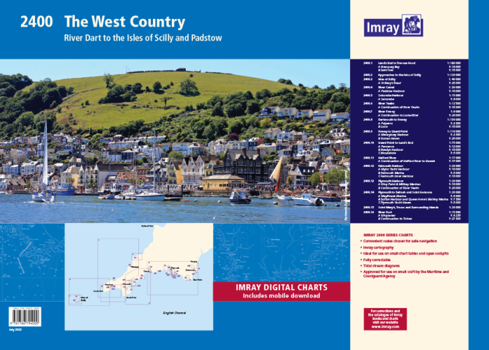
2400 West Country Chart Pack
River Dart to the Isles of Scilly and Padstow
Gegarandeerd de laaste editie en zonder verzendkosten.De 2000 serie zeekaarten van Imray zijn overzichtskaarten en detailkaarten op A2 formaat van verschillende populaire kustwateren van:
1. Nederlandse kust en de Waddenzee
2. De kustwateren van de Westzijde van Groot Brittanie.
3. Het Kanaal, zowel de Engelse als de Franse kust
4. De Thamesmonding en de Oostkust van Engeland
Op de cover / afbeedling van de betreffende kaartenset vindt u de editiedatum, de schaal en staan de diverse gedetailleerde havenaanlopen vermeld.
Ook staan daar alle kaarten die tot deze set behoren, met vermelding van de schaal.
Deze waterkaarten zijn ongevouwen tot A2 formaat en de afmeting is 590x420mm.
Tot er een nieuwe editie wordt uitgegeven kunt u correcties downloaden via de volgende link:
https://www.imray.com/corrections/
2400.1 Land’s End to Trevose Head
1: 180 000 WGS 84
Includes plans Newquay Bay (1:10 000) and Saint Ives (1:15 000)
2400.2 Approaches to the Isles of Scilly
1: 120 000 WGS 84
2400.3 Isles of Scilly
1: 40 000 WGS 84
Includes plan St Mary’s Road (1:25 000)
2400.4 River Camel
1: 30 000 WGS 84
Includes plan Padstow Harbour (1:10 000)
2400.5 Salcombe Harbour
1: 15 000 WGS 84
Includes plan Salcombe (1:9000)
2400.6 River Yealm
1: 12 500 WGS 84
Includes plan Continuation of River Yealm (1:15 000)
2400.7 River Fowey
1: 9000 WGS 84
Includes plan Continuation to Lostwithiel (1:20 000)
2400.8 Dartmouth to Fowey
1: 150 000 WGS 84
Includes plans Polperro (1:3500) and Looe (1:10 000)
2400.9 Fowey to Lizard Point
1: 110 000 WGS 84
Includes plans Mevagissey Harbour (1:3500) and Gorran Haven (1:30 000)
2400.10 Lizard Point to Land’s End
1: 75 000 WGS 84
Includes plans Penzance (1:12 000), Newlyn Harbour (1:10 000) and Mousehole (1:5000)
2400.11 Helford River
1: 17 000 WGS 84
Includes plan Continuation of Helford River to Gweek (1:17 000)
2400.12 Falmouth Harbour
1: 20 000 WGS 84
Includes plans Mylor Yacht Harbour (1:10 000), Falmouth Marina (1:5000) and Falmouth Inner Harbour (1:10 000)
2400.13 Plymouth Harbour
1: 20 000 WGS 84
Includes plans King Point & Millbay Marinas (1:10 000) and Continuation of River Yealm (1:20 000)
2400.14 Plymouth to Saltash and Saint Germans
1: 20 000 WGS 84
Includes plans Mayflower Marina (1:5000), Sutton Harbour and Queen Anne’s Battery Marina (1:7500) and Plymouth Yacht Haven (1:5000)
2400.15 Saint Mary’s, Tresco and Surrounding Islands
1: 20 000 WGS 84
2400.16 River Dart
1: 15 000 WGS 84
Plans Kingswear, Continuation to Totnes
On this edition the latest depth surveys have been applied. The chart of the River Dart has been reschemed to show larger scale coverage of Kingswear and Dartmouth. Harbour plans of Polperro and a larger scale (1:9000) plan of Salcombe are included for the first time. The harbour plan of Padstow has increased coverage to show greater detail of the approach.
A voucher code to download ID20 Imray English Channel charts into Imray Navigator (our app for iPad, iPhone and Android) is included with this atlas.
Chart 2400.8 (Start Point to Fowey) has been reschemed to include the approaches to Dartmouth. The chart scale remains the same. For this edition tidal stream information is included. There has been general updating throughout
Specificaties
| testdave3 | € 0,00 |
|---|---|
| Landen Europa | Verenigd Koninkrijk |
| Merk | Imray |
| Artikelnummer | 162400 |
| EAN | 9781786794000 |
| Serie | Imray Sets |
| Vaargebied | Het Kanaal |
| Taal | English |
Gratis én snelle verzending
Bij bestellingen boven de €50
Shop de wereld van watersport
Groot assortiment met meer dan 20.000 artikelen
Gemakkelijk retourneren
Online makkelijk geregeld
De winkel van Vrolijk Watersport

Stap binnen in de winkel van Vrolijk Watersport
Wij zijn dé watersportwinkel van Scheveningen, gelegen in het havengebied.
Onze ruim opgezette winkel heeft een compleet assortiment voor zeil- en motorboten. Ook voor uw persoonlijke uitrusting is er veel keus. Merken als Musto, Helly Hansen, Gill, Secumar, Spinlock, Harken, Cobb, Omnia, Wichard, de IJssel, Plastimo, Talamex, Imray, NV Charts, ANWB en Nebo zijn het hele jaar op voorraad.