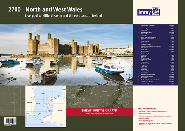
Imray 2700 North and West Wales
Kom langs in de winkel
Beschrijving
2700 North and West Wales Chart Pack
Liverpool to Milford Haven and the East Coast of Ireland
Gegarandeerd de laaste editie en zonder verzendkostenDe 2000 serie zeekaarten van Imray zijn overzichtskaarten en detailkaarten op A2 formaat van verschillende populaire kustwateren van:
1. Nederlandse kust en de Waddenzee
2. De kustwateren van de Westzijde van Groot Brittanie.
3. Het Kanaal, zowel de Engelse als de Franse kust
4. De Thamesmonding en de Oostkust van Engeland
Op de cover / afbeedling van de betreffende kaartenset vindt u de editiedatum, de schaal en staan de diverse gedetailleerde havenaanlopen vermeld.
Ook staan daar alle kaarten die tot deze set behoren, met vermelding van de schaal.
Deze waterkaarten zijn ongevouwen tot A2 formaat en de afmeting is 590x420mm.
Tot er een nieuwe editie wordt uitgegeven kunt u correcties downloaden via de volgende link:
https://www.imray.com/corrections/
In new A2 atlas format suitable for use on small chart tables and in the cockpit. Printed on high quality cartridge paper, this edition is wirobound and supplied in a durable plastic wallet.
The atlas includes:
2700.1 Liverpool Bay to Anglesey 1: 280 000 WGS 84
Plan Holyhead (1:27 500)
2700.2 Liverpool Bay 1: 145 000 WGS 84
Plan Liverpool (1:40 000)
2700.3 Anglesey and Menai 1: 145 000 WGS 84
Plans Conwy Bay (1:60 000), Conwy (1:30 000)
2700.4 Menai Strait and The Swellies 1: 70 000 WGS 84
Plans Bangor and Beaumaris (1:35 000), The Swellies (1:15 000), Port Dinorwic (1:15 000), Caernarfon (1:15 000), Llanddwyn Island (1:25 000)
2700.5 Southern Anglesey and Lleyn Peninsula 1: 145 000 WGS 84
Plan Porth Dinlläen (1:17 500)
2700.6 Cardigan Bay 1: 145 000 WGS 84
2700.7 Tremadog Bay 1: 80 000 WGS 84
2700.8 Cardigan Bay Plans 1: various WGS 84
Plans Abersoch (1:25 000), Pwllheli (1:12 500), Porthmadog (1:10 000), Mochras Lagoon (1:15 000), Barmouth (1:25 000), Aberdovey (1:25 000), Aberystwyth (1:18 000), Aberaeron (1:17 500), New Quay (1:20 000), Aberporth (1:30 000), Cardigan (1:40 000), Newport Bay (1:35 000), Fishguard (1:18 000)
2700.9 Aberaeron to St David’s 1: 155 000 WGS 84
2700.10 Dublin Bay to Anglesey 1: 280 000 WGS 84
Plan Dublin Bay (1:90 000)
2700.11 Cardigan Bay to South East of Ireland
1: 300 000 WGS 84
2700.12 St George’s Channel
1: 280 000 WGS 84
Plan Kilmore Quay (1:25 000)
This May 2016 edition has been updated throughout, with the latest known depth surveys and up-to-date wind farm information.
Specificaties
| testdave3 | € 0,00 |
|---|---|
| Landen Europa | Verenigd Koninkrijk |
| Merk | Imray |
| Artikelnummer | 162700 |
| EAN | 9781846237980 |
| Serie | Imray Sets |
| Vaargebied | Ierse Zee |
| Taal | English |
De winkel van Vrolijk Watersport

Stap binnen in de winkel van Vrolijk Watersport
Wij zijn dé watersportwinkel van Scheveningen, gelegen in het havengebied.
Onze ruim opgezette winkel heeft een compleet assortiment voor zeil- en motorboten. Ook voor uw persoonlijke uitrusting is er veel keus. Merken als Musto, Helly Hansen, Gill, Secumar, Spinlock, Harken, Cobb, Omnia, Wichard, de IJssel, Plastimo, Talamex, Imray, NV Charts, ANWB en Nebo zijn het hele jaar op voorraad.