


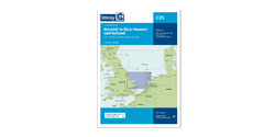


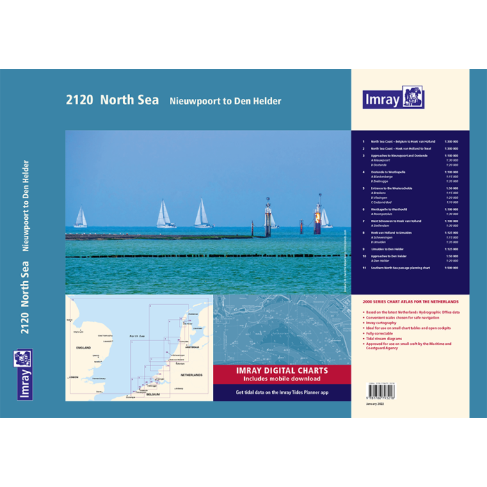
Imray 2120 Noordzee
Artikelnummer
162120
1-2 werkdagen levertijd
€ 86,95
Imray 2120 Noordzee
2120 North Sea - Nieuwpoort to Den Helder Chart Pack 2022
Nieuwpoort to Den Helder (including North Sea Passage Planning sheet)
Atlas voor de Nederlandse Kust van Nieuwpoort tot Den Helder met gratis alle Nederlandse Imraykaarten digitaal.Deze kaarten zijn ook digitaal beschikbaar.Elke kaartenset bevat een voucher om de ID 10 te downloaden op de app van Imray.
Geen Verzendkosten
De sets worden gebonden geleverd in een handige plastic hoes met de allernieuwste gegevens van de Nederland Hydrografische Dienst.
Alle relevante gegevens zijn op middelgrote en grote schaal in combinatie met beroemde haven plannen van Imray en essentiële getijden informatie.
Alle gegevens zijn bewerkt door de deskundige cartografen van Imray om een uniek en eerste keus product voor het zeilen op de Nederlandse kustwateren te bieden,
De 2000-serie atlassen zijn een logische uitbreiding op de vertrouwde en bekende gevouwen C-charts van Imray.
De laatste correcties : http://www.imray.com/corrections/
Part of Imray’s popular small format chart coverage for the Netherlands, this atlas is a convenient A2 format, wirobound along one edge.
It includes a voucher code to download ID10 Imray North Sea charts into Imray Navigator (our app for iPad, iPhone and Android).
It covers the North Sea coast from the Belgian-French border, through the Zeeland, South Holland and North Holland coasts up to and including Den Helder.
It includes all of the navigational charts and tidal data required for coastal passage and approach. Also included is a larger-format passage planning sheet for plotting routes across the North Sea.
1. North Sea Coast – Nieuwpoort to Hoek Van Holland (1:300 000)
2. North Sea Coast – Hoek van Holland to Texel (1:300 000)
3. Approaches to Nieuwpoort and Oostende (1:100 000) includes plans Niewpoort (1:30 000) and Oostende (1:20 000)
4. Oostende to Westkapelle (1:100 000) includes plans Blankenberge (1:15 000) and Zeebrugge (1:35 000)
5. Entrance to the Westerschelde (1:50 000) includes plans Breskens (1:15 000), Vlissingen (1:20 000) and Cadzand-Bad (1:10 000)
6. Westkapelle to Westhoofd (1:100 000) includes plan Roompotsluis (1:30 000)
7. West Schouwen to Hoek van Holland (1:100 000) includes plan Stellendam (1:30 000)
8. Hoek van Holland to IJmuiden (1:125 000) includes plans Scheveningen (1:15 000) and IJmuiden (1:35 000)
9. IJmuiden to Den Helder (1:125 000)
10. Approaches to Den Helder (1:50 000) includes plan Den Helder (1:20 000)
11. Southern North Sea passage planning chart (1:500 000)
This edition includes the latest depth surveys and windfarm details along with adjusted routes across the North Sea. There has been general updating throughout.
Commended for the John C Bartholemew Award for Thematic Mapping at the 2016 British Cartographic Society Awards.
| Landen Europa | België, Nederland |
|---|---|
| Artikelnummer | 162120 |
| Externe_Barcode | 9781786791962 |
| testdave5 | 0,00 |
| Serie | Imray Sets |
| Vaargebied | Noordzee |
| Taal | English |
Advies nodig?
Verzenden
- Boven de € 50,- gratis verzonden.
- Imray uitgaven worden altijd gratis verzonden.
- Voor 16:00 op werkdagen besteld de volgende dag in huis.
Viewed by others