


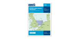


Imray 2900 Upper Clyde Chart
Artikelnummer
162900
1-2 werkdagen levertijd
€ 79,99
Imray 2900 Upper Clyde Chart
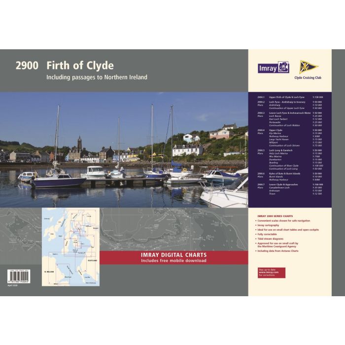
2900 Firth of Clyde Chart Pack Wiro Bound
Includes passages to Northern Ireland
This complete redesign of our 2900 Firth of Clyde chart pack now include more detailed coverage of the area and comes as a paper and digital edition.Created in association with the Clyde Cruising Club for use alongside their sailing directions, coverage includes detail of this delightful area of Scotland with passages to Northern Ireland and references to the popular large scale Antares Charts.
The 16 sheets in this pack provide all the necessary information for passage planning, detailed approach to yacht havens and marinas, and the numerous anchorages and sailing areas recommended for small craft.
Coverage includes the Firth of Clyde, lochs to the north of the Upper Clyde, the Kyles of Bute and Loch Fyne, and Kilbrannan Sound to the Mull of Kintyre. This expanded edition also includes coverage of the North Channel, detailing passage from the Firth of Clyde and Loch Ryan to Belfast Lough.
In A2 format, wiro-bound in a tough plastic wallet. Also available in loose-leaf A2 format in a tough plastic wallet, please refer to stock code ICic2900-2.
Imray Digital Charts: Free mobile download
A voucher code to download ID30 Imray digital charts into Imray Navigator (our app for iPad, iPhone and Android) is included with this pack.
Charts included:
1. Firth of Clyde (1:210 000)
2. The North Channel (1:210 000)
3. Aisla Craig to Ayr (1:75 000) includes plans Girvan (1:6000), Ayr (1:10 000)
4. Ayr to Ardrossan (1:75 000) includes plans Troon (1:12 500), Irvine (1:17 500), Ardrossan (1:10 000)
5. Pladda to Lamlash Harbour (1:30 000)
6. South of Bute & the Cumbraes (1:30 000) includes plans MiIlport (1:15 000), Largs Yacht Haven (1:15 000)
7. Upper Clyde (1:50 000) includes plans Kip Marina (1:15 000), Rothesay Bay (1:10 000), Rothesay Harbour (1:5000)
8. Long Loch & Gareloch (1:50 000) includes plans Continuation of Long Loch (1:50 000), Continuation of River Clyde (1:100 000), Dumbarton (1:15 000), Bowling (1:15 000), Approaches to Rhu (1:15 000), Holy Loch Marina (1:12 500)
9. Kyles of Bute (1:30 000) includes plans Continuation of Loch Striven (1:30 000), Continuation of Loch Riddon (1:30 000), Port Bannatyne Marina (1:10 000), Burnt Islands (1:10 000), Caladh Harbour (1:10 000)
10. Inchmarnock Water (1:30 000)
11. Lower Loch Fyne (1:50 000) includes plans Portavadie (1:25 000), East Loch Tarbert (1:8000), Ardrishaig (1:10 000)
12. Upper Loch Fyne (1:50 000) includes plans Continuation of Loch Fyne (1:50 000), Loch Gair (1:25 000), Minard Narrows (1:25 000), Invaray (1:25 000)
13. Inchmarnock to Kilbrannan Sound (1:50 000) includes plan Loch Ranza (1:22 500)
14. Carradale to Sanda Island (1:75 000) includes plans Campbeltown Loch (1:35 000), Campbeltown Harbour (1:7500), Sanda Island (1:30 000)
15. Aisla Craig to Loch Ryan (1:75 000) includes plan Stranraer (1:12 500)
16. Belfast Lough to Carnlough (1:90 000) includes plans Carrickfergus (1:15 000), Bangor Bay (1:17 500)
| Landen Europa | Ierland, Verenigd Koninkrijk |
|---|---|
| Artikelnummer | 162900 |
| Externe_Barcode | 9781786792044 |
| testdave5 | 0,00 |
| Serie | Imray Sets |
| Vaargebied | Ierse Zee |
| Taal | English |
Advies nodig?
Verzenden
- Boven de € 50,- gratis verzonden.
- Imray uitgaven worden altijd gratis verzonden.
- Voor 16:00 op werkdagen besteld de volgende dag in huis.
Viewed by others